AeroNOTAM Help
Please read the disclaimer first
AeroNOTAM is not for navigational and/or operational use.
No subscription – limited mode
You can still use AeroNOTAM in a limited way if you have none or an expired subscription. AeroNOTAM allows you to show NOTAMs for one airport (including its FIR) only. The automatic generated route “Free Location” contains one editable airport. The “Radius Search” switch is not changable. Already defined user routes are grayed out and is not selectable until subscription is renewed. In limited mode the top bar is colored in orange.
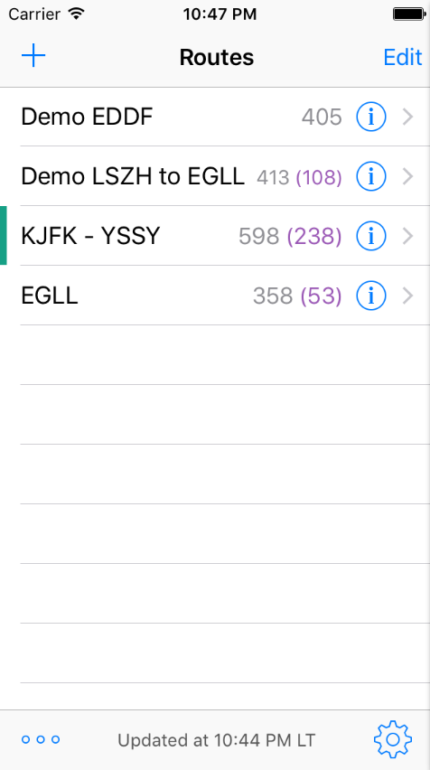
Routes View
In the “Routes” view, select, add, change or delete a route. To manually refresh all defined routes, swipe down the routes list and NOTAMs will be loaded. However, AeroNOTAM supports also Apple’s background fetching, which (when enabled) loads new NOTAMs approximately every hour (you might want to disable this in the device settings when using roaming).
|
|
If you start AeroNOTAM for the first time, two demo routes will be generated automatically (which you can of course remove).
The number of NOTAMs (in parentheses the number of new NOTAMs) is displayed after the route name. A horizontal green bar indicates routes, if the “Notify when updated” option is switched on (notifications about new or changed NOTAMs). This notification informs you that any new NOTAMs have been loaded for this particular route. Choose Choose |
Route types and definitions
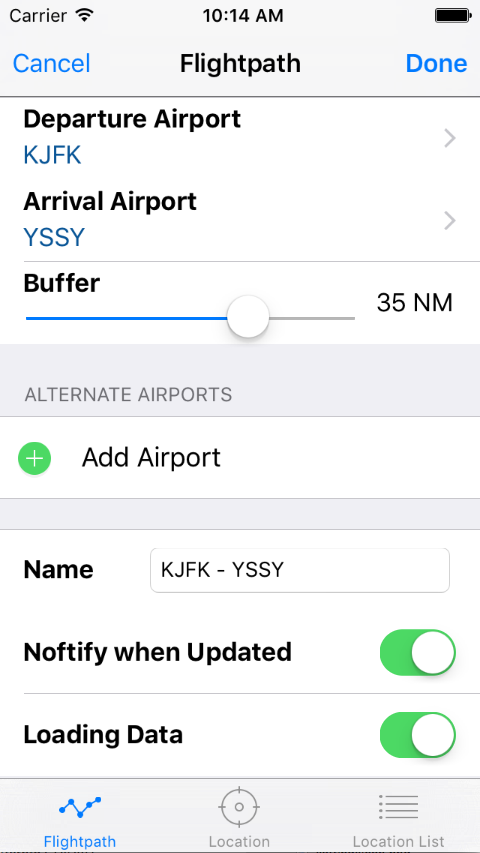
To add a new route, fill in the route data in one of the three route types (“Flightpath”, “Location” or “Location List”).
- Flightpath contains “From Airport”, “To Airport” and (optional) alternate airports. NOTAMs from en-route airports in buffer distance and FIRs are also included.
- Location defines a single airport and nearby airports within the selected radius. FIRs are also included.
- Location List defines arbitary list of airports.
 Route Type: Flightpath Route Type: Flightpath |
Built-in airports can be choosen by ICAO, IATA or airport name. Data is provided by US FAA which covers most airports. However, they might not cover smaller airfields or local NOTAM series outside the US. FIRs are automatically added for each defined airport.
A “Buffer” defines the flightpath width and the radius around “Airport From/To” of included enroute airports with their observed NOTAMs Enable “Notify when updated” to receive a notification that new data is availbe for this route (see also Alerts in the Settings view) Only routes which have their “Loading Data” Switch enabled will be loaded (manuall or automatic background loading). |
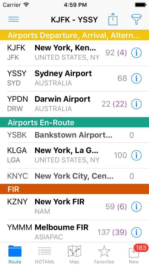
Route View
 Route View Route View |
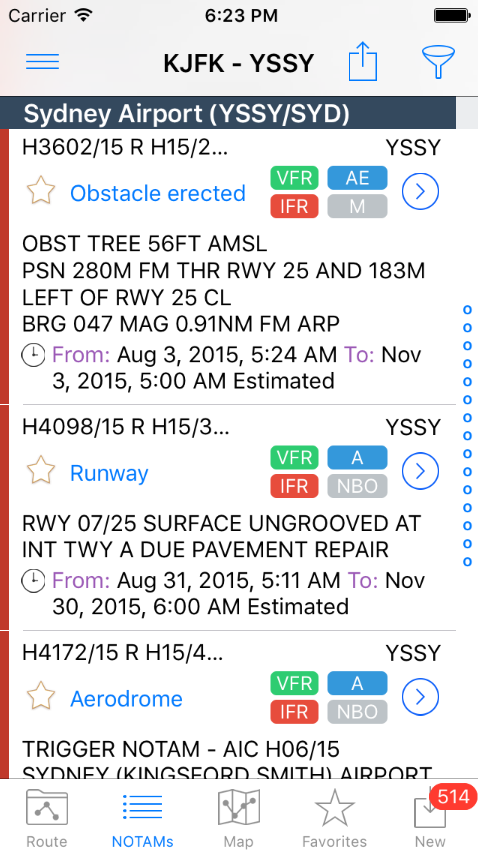
A red filter icon Choose an airport or FIR and the appropriate NOTAMs will appear. A “New” item will appear in the tab bar if new NOTAMs are available. |
 Filter Filter |
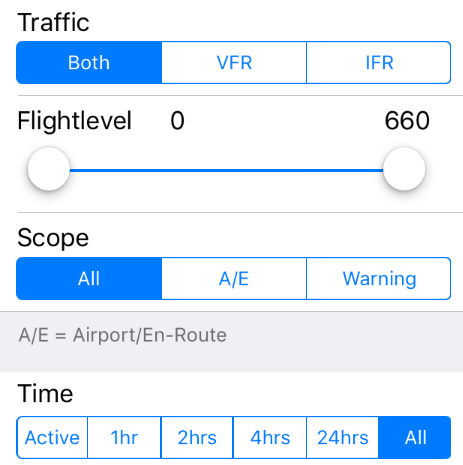
The filter reduces the amount of unneeded NOTAMs. The filter is applied within the selected route only (each route can have different filter settings). |
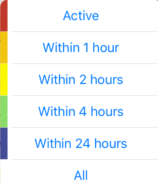 Time Filter (iPad) Time Filter (iPad) |
On iPad the “Time Filter” is a separate pull down menu for faster access.
You can filter NOTAMs with by its activation time (colored bar) |
 Alerts & collapsed NOTAMS |
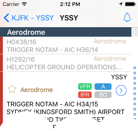
If you choosen an airport or a FIR the appropriate NOTAMs will appear.
Tapping on NOTAM marks it as read (collapsed view). Defining alerts |
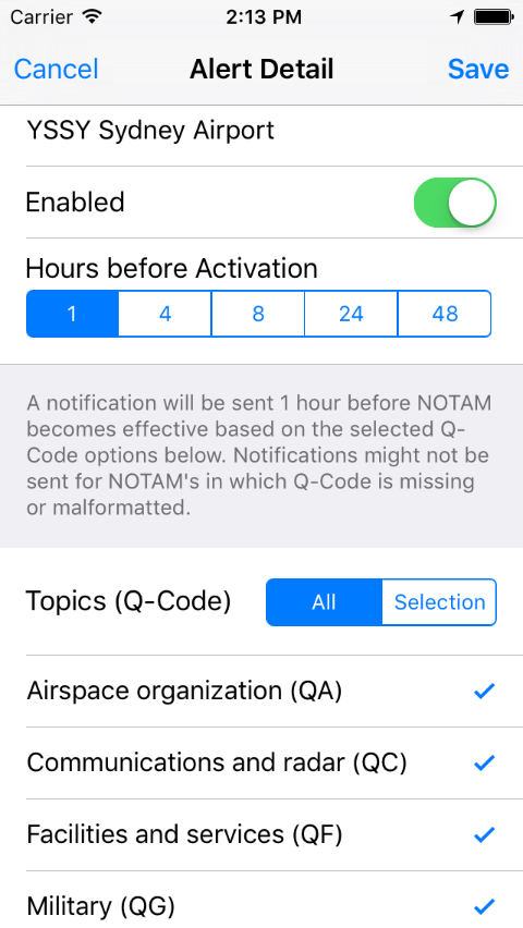
Alert View |
Alerts can be defined for each airport or FIR to get notifications before NOTAMs become active.
For a overview of all defined alerts go to |
Notam View
 NOTAM view NOTAM view |
NOTAMs can be selected Other labels shows the NOTAMs flightrules (VFR/IFR) and the scope and purpose of a NOTAM which are describe below. |
NOTAM view labels
| The blue indicator represents the scope of a NOTAM. | |
| There are the following letters (or combinations): A = Aerodrome E = En-Route W = Warning K = Checklist |
|
| The yellow indicator represents warnings |
| The gray indicator represents the purpose of a NOTAM. | |
| There are the following letters (or combinations): N = NOTAM selected for the immediate attention of aircraft operators B = NOTAM selected for PIB entry O = NOTAM concerning flight operations M = Miscellaneous NOTAM; not subject for a briefing, but it is available on request K = NOTAM is a checklist |
Map view
Depending on “Filter” and “Map Settings” airports and NOTAMs of the selected route will be shown on the map. Find the meaning of the “NOTAM map symbols” and the “Airport map symbols” below. If available, the operational radius of a NOTAM is displayed as circle. Tap the map symbol for more information.
NOTAMs of airports not defined in the route (![]() “other airport”) can be obtained simply by tap on its symbol ant then tap on
“other airport”) can be obtained simply by tap on its symbol ant then tap on ![]() in the callout.
in the callout.
The ![]() icon opens “Map Settings”.
icon opens “Map Settings”.
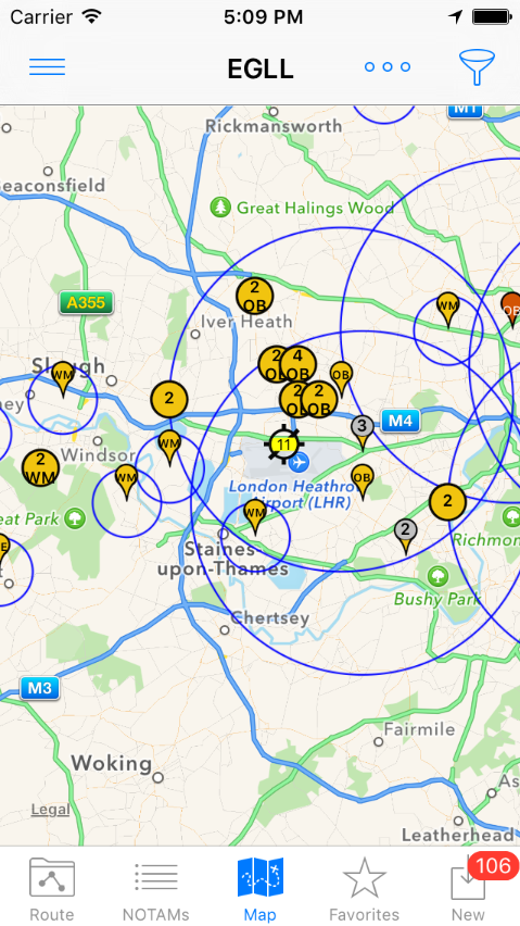 Map View Map View |
|
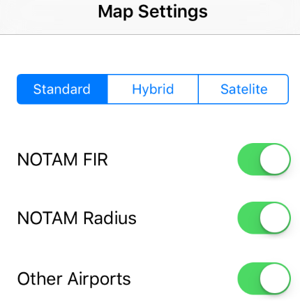 Map Settings Map Settings |
The “Map Settings” determine the visual representation on the Map only. |
NOTAM Map Symbols
![]() NOTAM from FIR with exact coordinates (1)
NOTAM from FIR with exact coordinates (1)
![]() NOTAM from FIR with approximative coordinates (1)
NOTAM from FIR with approximative coordinates (1)
![]() NOTAM from Airport with exact coordinates (1)
NOTAM from Airport with exact coordinates (1)
![]() NOTAM from Airport with approximative coordinates (1)
NOTAM from Airport with approximative coordinates (1)
![]() clustered NOTAM from Airport (2). Zoom in will uncluster
clustered NOTAM from Airport (2). Zoom in will uncluster
![]() more than one NOTAM from FIR with exact same coordinates (2)
more than one NOTAM from FIR with exact same coordinates (2)
![]() more than one NOTAM from FIR with approximative same coordinates (2)
more than one NOTAM from FIR with approximative same coordinates (2)
![]() more than one NOTAM from Airport with exact same coordinates (2)
more than one NOTAM from Airport with exact same coordinates (2)
![]() more than one NOTAM from Airport with approximative same coordinates (2)
more than one NOTAM from Airport with approximative same coordinates (2)
(1) NOTAMs show their “subject code”
(2) NOTAMs show the number of NOTAMs for its coordinates
Airport Map Symbols
![]() Airport departure
Airport departure
![]() Airport departure containing NOTAM (3)
Airport departure containing NOTAM (3)
![]() Airport arrival
Airport arrival
![]() Airport arrival containing NOTAM (3)
Airport arrival containing NOTAM (3)
![]() Airport enroute
Airport enroute
![]() Airport enroute containing NOTAM (3)
Airport enroute containing NOTAM (3)
![]() Airport alternate
Airport alternate
![]() Airport alternate containing NOTAM (3)
Airport alternate containing NOTAM (3)
![]() other Airport, not part of the defined route (adhoc NOTAM download possible)
other Airport, not part of the defined route (adhoc NOTAM download possible)
![]() A6 – clustered other airport (4). Zoom in will uncluster
A6 – clustered other airport (4). Zoom in will uncluster
(3) Airports show number of NOTAMs (in a radius of 0,5 NM)
(4) Airport cluster shows number of clustered airports
Alerts
In the “Routes view” choose ![]() for the settings and there “Alerts”. Define alerts for airports or FIRs with selectable NOTAM Q-Code topics.
for the settings and there “Alerts”. Define alerts for airports or FIRs with selectable NOTAM Q-Code topics.
Database update
In the settings choose “Airport Database Update” to manually check for updates and update the AeroNOTAM Database. The app checks periodically whether data updates are available.