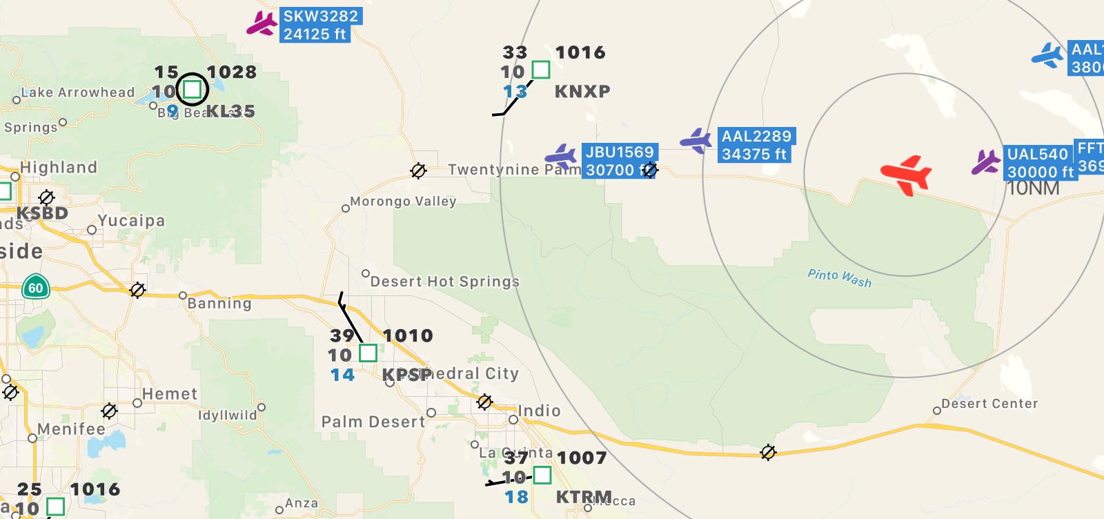
Shows aircraft traffic from your ADS-B receiver (supporting GDL 90)

Requires iOS 17 or higher and a GDL 90 compatible ADS-B Receiver. Available for iPhone and iPad.
Receives and displays aircraft traffic data on map from ADS-B receivers (e.g., Stratux, ADSBee, SkyEcho) which support GDL 90 protocol output).
Expects GDL 90 data to be sent to port 4000 via UDP (which is usually standard; but can be changed in the app). Works entirely independent from internet connection (except for Apple map data; simple built-in map can be used instead) and with ADS-B receiver only.
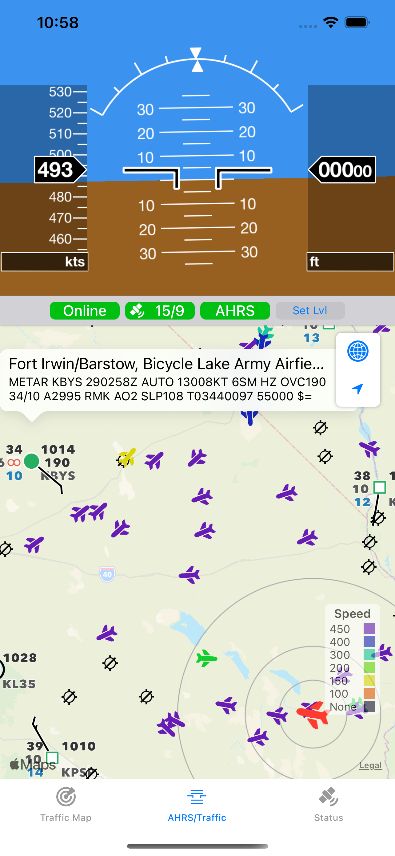
It also includes an attitude and heading reference system (AHRS) including airspeed, altitude, and heading as well as display of METAR/TAF (one-time unlock necessary).
Check our connection guide for help connecting to the stratux device.
The map display can be customized in different ways:
- Use top corner buttons to:
- configure aircraft data (altitude, callsign, climb rate, or speed)
- show distance rings (10, 20, 40 NM)
- change map type (Apple map or simple built-in offline map)
- tap on location button to toggle between tracking and none-tracking
- Tap on bottom right legend plate to toggle between speed and altitude
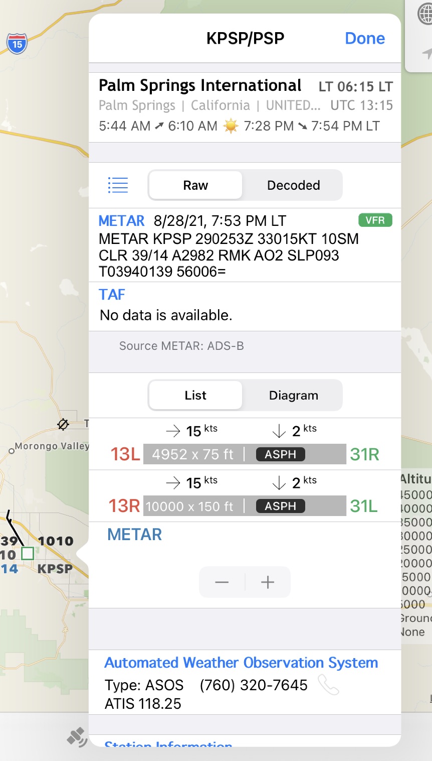
- Display of surrounding airports
The top center view shows own aircraft’s speed, track, and altitude. It also show number of satellites seen and used for tracking.
Unlock Data/Functionality
(available in Status > Settings)
AHRS and weather data can be displayed thru one-time unlock purchase. Currently supported are METAR and TAF. Additional airport data like runways, AWOS is also available thru built-in database (no Internet access required).
NOTE: weather data is available in areas with ADS-B data coverage. Please check before purchase, otherwise no weather will be shown.
Version History
V 1.4.4 – 20-MAY-2026
- Improved traffic symbols on map
- Minor internal fixes
- Updated airport database (2026-05-14)
V 1.4.3 – 02-MAY-2026
- Fixed possible crash at start with ADSBee device
- Updated airport database (2026-04-16)
V 1.4.2 – 27-MAR-2026
- Added ADS-B receiver info and improved device identification
- Added appearance option (light/dark)
- Updated airport database (2026-03-19)
V 1.4.1 – 22-JAN-2026
- Minor internal improvements
- Updated airport database (2026-01-22)
V 1.4 – 17-SEP-2025
- Adapted for iOS/iPadOS 26
- User interface optimizations
- Minor internal improvements
- Updated airport database (2025-09-04)
V 1.3.9 – 13-JUL-2025
- Minor internal improvements
- Updated airport database (2025-07-10)
V 1.3.8 – 23-JAN-2025
- Enhanced map content size and tab bar on iPadOS 18
- Minor internal improvements
- Minor bug fixing (unlock purchase)
- Updated airport database (2025-01-23)
- Requires at least iOS 15
V 1.3.7 – 05-SEP-2024
- Minor internal improvements
- Updated airport database (2024-09-05)
V 1.3.6 – 17-DEC-2023
- Minor internal improvements
- Updated airport database (2023-11-30)
V 1.3.5 – 14-JUL-2023
- Added option to manually configure IP address for Stratux devices
- Internal optimizations (e.g., improved connectivity)
- Updated airport database (2023-07-13)
V 1.3.4 – 15-JUN-2023
- Improved communications data (airport frequencies and AWOS)
- Internal optimizations
- Updated airport database (2023-06-15)
V 1.3.3 – 29-DEC-2022
- Minor UI improvements
- Minor METAR/TAF decoder improvements
- Updated airport database (2022-12-29)
V 1.3.2 – 16-AUG-2022
- Minor improvements (AHRS update rate, ADS-B device detection; GPS accuracy indicator)
- Minor layout improvements
- Updated airport database (2022-08-11)
V 1.3.1 – 27-JUN-2022
- Added slip/skid indicator in AHRS
- Improved display of traffic on map when no own position is available
- Minor improvements in settings
- Minor bug fixing
- Updated airport database (2022-06-16)
V 1.3 – 10-MAR-2022
- Added AHRS display including altitude, airspeed, and heading (as part of one-time unlock)
- Minor bug fixing
- Updated airport database (2022-02-24)
V 1.2.3 – 27-JAN-2022
- Added connection to pre-defined WiFi network name at app startup (in preferences)
- Minor bug fixing
- Updated airport database (2022-01-27)
V 1.2.2 – 04-DEC-2021
- Added disabled screen-lock option
- Minor bug fixing (e.g., removed control characters in METAR/TAF, improved connectivity handling)
- Updated airport database
V 1.2.1 – 13-OCT-2021
- Added airports layer on map with additiAdded customizable UDP port in settings
- iOS 15 adaptations
- Minor bug fixing
- Updated airport database
V 1.2 – 19-AUG-2021
- Added airports layer on map with additional information (e.g., runways, AWOS) surrounding current position
- Added import and display of METAR/TAF data from ADS-B data feed (available in regions with ADS-B data coverage only; requires one-time unlock)
V 1.1 – 19-JUL-2021
- Added customizable aircraft data for annotations
- Added optional distance rings and scale in map view
- Minor decoder improvements
- Minor layout changes
V 1.0 – 11-MAY-2021
- Initial Version